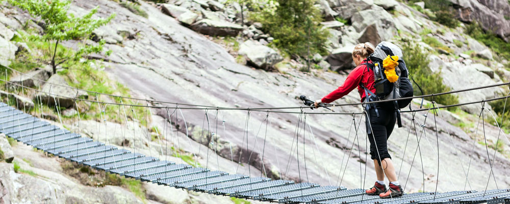
Famously known as the Whiskey Route to distinguish it from the Marangu route (which is known as the Coca Cola Trail), the Machame Route takes in some of the finest parts of the mountain, including the beautiful Shira Plateau, the Barranco wall and the majestic Lava tower. Surprisingly statistics show that the Machame Route offers a higher chance of reaching the summit too.

We offer the Machame route as a 6-7 days climb. The six days itinerary does not have an overnight stay at the Karanga campsite on day 4.
Lorem ipsum dolor sit amet, ei per elitr persecuti adipiscing, ne discere temporibus nam.
Lorem ipsum dolor sit amet, ei per elitr persecuti adipiscing, ne discere temporibus nam.
Lorem ipsum dolor sit amet, ei per elitr persecuti adipiscing, ne discere temporibus nam.
Lorem ipsum dolor sit amet, ei per elitr persecuti adipiscing, ne discere temporibus nam.

Elevation; 1828m/5997 ft - 3032m/9948 ft
Distance: 10.75km/6.68 miles
Altitude Gained: 1210m/3969 ft
Climatic zone: Montane forest/Rainforest
The adventure begins at around 8am when our guide arrives to pick you up from your hotel and take you to Machame Gate (1828m), a two to two and half hours drive through small towns and the cultivated lower slopes(the first climatic/vegetation zone) all the way to the Machame gate where registration and weighing of luggages are the two necessary activities that must be done before the hike starts.
The first day of the trek takes you into the Montane forest - the second vegetation zone of the mountain starting at Kilimanjaro's lower slopes. A steep walk of 10.5km which will take 4-5 hours, though there is plenty to catch your eye as we look out for some of Kilimanjaro's unique flora and fauna as well as colobus and blue monkey and other creatures of the forest. We will also break for lunch while in the forest depending on the timing of the day.
The Machame Camp/hut lies at 3032m which is right at the edge of the forest, with views over the treetops to the plains below. Your porters will already have your tents ready and the kitchen crew busy preparing dinner.

Elevation: 3032m/9948 ft - 3850m/ 12631 ft
Distance: 5.3km/ 3.3 miles
Altitude Gained: 818m - 2684ft
Climatic zone: Semi Alpine Moorland/Heather zone
Once again the second day involves a steep trek as we leave the forest behind and pass through the Heath and Moorland zone - Kilimanjaro's third vegetation zone. (There are five vegetation zones on the mountain) During day two if we are lucky enough we might be able to catch our first glimpse of Kibo, the snowy highest peak of Kilimanjaro and our ultimate destination. Mount Meru, Tanzania's second highest mountain is also visible during today's trek. You will notice, too, that our guide(s) will be setting a slower pace from today onwards, to help everyone acclimatize to the altitude.
On our way to the Shira cave once again we will be distracted by many eye-catching flora such as the giant lobelia and many others - and breathtaking views of the mountain and neighboring landscapes.
Our final destination on this second day is the Shira Cave Campsite which is one of the three campsites located along the Shira plateau and you can have a good view of Kilimanjaro's oldest famous third peak ( The Shira peak). As with every campsite on the route, your tent will be erected and lunch will be served upon arrival, followed by dinner later in the evening.

Elevation: 3850m/ 12631ft - 3986 m/ 13077 ft
Distance: 10.75km/6.7miles
Altitude Gained: 147m/482 ft (788m/2585ft up to Lava Tower, then a descent of 641m/2103ft)
Climatic zone: Semi Alpine Moorland and Alpine desert.
The morning begins with a long trek crossing the Shira plateau as we head due east towards Kibo. It's a very photogenic trek with the snowy summit of Kilimanjaro constantly present ahead.
Our trek takes us to the Lava Tower, at the foot of Kibo where lunch will be saved. We are now cruising into some serious altitude, with Lava Tower standing at 4530m in the Alpine desert - Kilimanjaro's fourth vegetation zone. For this reason, it is normal for people to have symptoms of Acute Mountain Sickness,commonly a slight headache when they finally reach our campsite for the evening, Barranco Camp, following a steep descent to 3986m. This is entirely normal, and only concerning if the symptoms persist. Barranco is the prettiest campsite on the route, set amongst a nice garden of senecio against the south face of Kibo and of course at this Campsite you are now back to the Heath and Moorland zone Snacks and then dinner is served in the evening.

Elevation: 3986m/13077ft - 4662m/15295ft
Distance: 8.5km/5.3 miles
Altitude Gained: 676m/2217ft
Climatic zone: Alpine desert.
Today is a short day of trekking distance but with a reputation of being hard as you enter high altitudes, however you will spend most of the trek today in Kilimanjaro Alpine desert - make sure you are fully rested and relaxed in order to prepare you for the extra long day tomorrow. Nevertheless, the start of today is a bit of a suprise as you immediately start by facing the Barranco Wall. Taking over an hour to climb, you may need to use your hands on occasions to pull yourself up the rocks but please don't be over-concerned - this is not mountaineering, the wall is rather challenging but not dangerous.
At the top of the Barranco wall the path drifts and meanders gently to the Karanga Valley, a beautiful little place where malachite sunbirds jump from flower to flower. If we were on a seven-day trek we would find our campsite (Karanga) at the top of the other side of the valley, a steep but short climb up from the Karanga stream. Both lunch and dinner will be served at this campsite. But for a six-day climb we will have lunch at the Karanga Campsite then trek for three more hours or so as we traverse the southern side of Kibo, walking through a spectacular lunar landscape on our way to Barafu Camp, on the south-eastern shoulder of Kibo.
Here we will rest, take dinner, and try to get some sleep before the tough climb of the night ahead…

Elevation;4662m/15295ft - 5745m/18848ft
Distance: 4.86km/ 3.01 miles
Altitude Gained: 1233m/4045ft
Climatic zone: Arctic zone/ Summit zone.
Arising at around midnight, we begin our slow hike up to Stella Point (5745m) on the rim of the Kibo Crater. It's a steep, slow, cold trek and a good test of your physical and mental endurance - this is where your Kilimanjaro certificate is earned. Provided you have avoided altitude sickness and have acclimatized well, there is no reason to give up. The Stella Point stands at the Ice- cap zone - Kilimanjaro's fourth vegetation zone. This is a 5-6 hours walk, though it can be much longer depending on your condition and pace.
From Stella Point it is only about 45 minutes further on,walking past glaciers and snowfields and with views over the Kibo Crater, to Uhuru Peak - at 5895m the highest point in Africa! Here, if we're on time, we can watch the sunrise over the African continent, take photos,take a brief rest and immediately start your mandatory descent down to Barafu and later on to Mweka huts

Elevation; 5895m/19341ft-3106m/10190ft
Distance; 11.5 km/7.1miles
Altitude Lost; 2789m/9150ft
Climatic zone: Arctic zone- Alpine Desert- Semi Alpine Moorland.
After a brief rest at the top, we continue back down to Barafu Camp - a tough walk given that you've used up almost your entire energy reserves going up. At Barafu we take breakfast and relax for an hour, before continuing our walk down the mountain, this time on the Mweka Trail. Today's trek takes us back down through the alpine desert, heath and moorland zones until we once more enter the forest zone via Millennium Camp (3827m). There, at the edge of the forest, we find the Mweka Campsite (3106m), our final stop on the trek. You have been walking for around 16 hours, many short breaks! Exhausting but, if you made it to the top, you'll be celebrating the achievement. NOTE THAT, Judging from your condition after a long and brutal walk to the summit and down to Barafu, your guide will decide on the final stop of the day between Millennium and Mweka Campsite.

Elevation:3106m/10190ft-1633m/5357.6ft
Distance: 9.1km/5.7miles
Altitude Lost: 1473m/ 4832.6ft
Climatic zone: Montane forest.
It's just a few hours further now from the campsite to Mweka Gate (1633m), where those who made it to the summit or Stella Point will collect their certificates. A car will be waiting to take you back to your hotel for warm showers and cold beers. Your trek is at an end. Your guide will tell you what to do and you will have a chance to say thanks to the whole team before you part ways.
Lorem ipsum dolor sit amet, ei per elitr persecuti adipiscing, ne discere temporibus nam.
| Date | Solo trekker in a private trek | 1 trekker in a public trek | 2 trekkers in a public trek | 3+ trekkers in a public trek |
|---|---|---|---|---|
| 25-30 August 2024 | 2899 | 2199 | 2099 | 1999 |
| 3-8 November 2024 | 2999 | 2299 | 2199 | 2099 |
| 3-8 November 2024 | 2999 | 2299 | 2199 | 2099 |
| 6-12 December 2024 | 2999 | 2299 | 2199 | 2099 |